 Start to #2
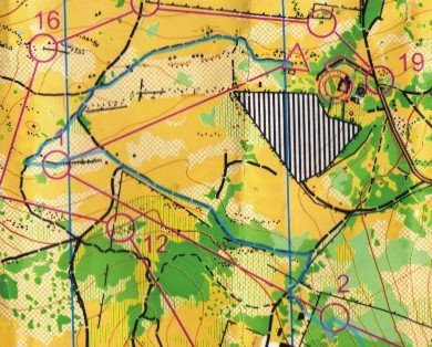
 From #2 to #3 I started by heading for open terrain and the saddle between the two hills. I found a really good quality new jeep track in this saddle, that isn't marked on the map. I hit the road that comes down the hill and cut straight across on to the path. Having come from just to the North of the saddle I knew that I needed to turn left on to the trail. My next key focus was to hit the 'dog leg' on the path and then to head off. This is where I made my mistake. I was spot-on in the right place when I left the path but instead of heading due East, I started contouring around the hill, searching for cliffs. I did find cliffs (not marked on the map) but things really were not fitting the picture. I looked up and saw the main body of the hill right above me! I'd headed too far North. So, up I went, aiming to hit on to the path again instead of messing around in the bushes as I wasn't sure of my altitude. So, I hit the path, ran South, turned off the path at exactly the same place as I'd been before. And, I hit the control spot-on within seconds. Arrrrggghhh!
 Leaving #3 I thought it would be a nice idea to hit that nice 'road-not-on-the-map' to see where it went. But, I hit the trail and ran along it; forgetting that I needed to cross over one more bit to get the main 'road'. I realised this when I didn't find the new road after about 50-metres - Eureka! I was still on the path. This is the one thing... when you make a mistake you have to forget it and just keep going. Makes your mind go crazy. Anyway, I took off cross-country and crested the hill next to the bare rock (purple/lilac shading on the map; top of the hill) and went down the other side to hit the path.
 I have a slight advantage when it comes to getting quickly onto the path across the river... I cut the path! Hahaha. I cut the trail in early 2007 for my SPUR Adventure event, which was held at this venue. It provides a super access route from the bottom area to the top. You can get down fairly easily down a 'cliff', by holding on to trees, but the path is a nicer option, especially for coming back up.
Once across the river #6 was first on my hit-list. Nice clean section leading up to the fenced structure with the wall. Walked alonside the wall and towards the re-entrant (note the v-shaped contours and the small brown dots that indicate a dry ditch). Easy one.
From #6 to #7 was also nice. Straight across towards the saddle and along the rocked vegetated section to the control.
From #7 to #8 I took a sweet line contouring around the hill. The only tricky part with this is knowing when you've gone around enough. As I started dropping down I could see a big building, which I didn't see on the map. My saving grace was the tar road (indicated as a brown road on the map). I aligned myself to the road where it comes straight down the hill. Just before I got to the control (about 15m away) I saw Cobus (and two others; can't remember who!). They'd been searching for ages.
#8 to #9 was also straight forward. Again contouring is tricky so I contoured and descended at the same time. By the time the slope had flattened I could see that vegetated 'stripe', which I'd passed from #6 to #7. I took a quick bearing from here to where I wanted to go. I was slightly lower than the area where the control was located. I shot off in a straight line and as I neated I could see the vegetated clump (thicket) where the control would be. Nice one.
#9 to #10 was again fairly straight forward. I headed for the wall again and then towards the buildings and then across open ground to the road. Only tricky part here is not to overshoot - so I first used the shape of the road (slight kink) and then ran just off the road, keeping an eye on the dry riverbed behind the trees. The control is marked on those dotted brown lines. I can't think of the word for the feature... a bit of an erosion re-entrant thing. Hit the control and headed back across the river and up my path.
From #10 to #12
 OK, across the river and on to the path, heading West. I could see the barerock (actually slate quarry excavations) mounds on my right (North of the path). The road turning off was evident and the control was in a pit (slate excavation) under a tree. Nice.
#11 to #12 I decided to just go cross-country again. Quite grassy but otherwise open. My aim was to hit the main North-South path, which I did. Then it was easy to just follow the path. The next tricky part is to decide where to turn off the path to hit the control. I was looking for any sign of an old fence. Done. I followed the fence for a bit, aiming for the control a few metres off the fence.
#12 to #16 From #12, back onto paths to #13. Trick here was when to leave the path. I took a bearing from the path, using the rocky vegetated feature to the East, just off the path. And, I headed off. I lost time on this control because I didn't go far enough at first. There were a few of us around here. I go to that first main boulder cluster in the light green. At this point I'd already dropped a bit of altitude and this is what confused me. I started heading back and then realised that I hadn't gone far enough. I turned around again and spotted the control about 50m ahead. How cool! I was in perfect alignment with the control; totally unintentional!
#13 to #14 was also fairly straightforward. I just whacked through the grass heading for the road. I came out on to the road with open ground ahead, not the green vegetation. Crossed the road and fence and started through the open grassy area. I could see the 'valley', with reeds, to my right. Still a distance away I could see the control. nice and easy. There were a few of us around here (Tim, Eugene and Tania). When I saw Tania I blurted, "Goodness gracious, don't tell meI've been out here for ages!". I knew that she would have started after me. She clarified that she'd started about 13-minutes after me. Oh dear! #3 and lots of walking had cost me a big chunk.
#14 to #15 was also pretty easy. The vegetation feature were quite clear, like those three green dots to the right (South-east) of my track. Just past these the main vegetated section to my left 'dented in'. And here there was an embankment - and the control.
#15 to #16: Back on to the road. An option could have been to go as the crow flies, but as I was itching from the grass and covered in blackjacks - and sporting scratches from the wag-n-bietjie bushes, I thought the path would prove faster and friendlier. So, up the path I went, following it to the junction and then crossing diagonally towards #16. Key feature is that black line, which seems to have been some kind of stone wall / embankment thing. I went along the bottom it so I didn't see it from the top. Control very visible and a few orienteers around here.
From #16 to the FINISH

There was an 'elephant track' from #16 through to #17. An elephant track is a clear 'path' made my many feet running through grass, flattening it. Thank goodness Tim was just in front of me because I got to 17 and thought it wasn't mine. I already had my eye on #18. Doh! I punched and headed for 18. The fence was definitely not all there; more so closer to #18, which was on the eastern side of a small corrugated iron water reservoir (I think that is what it is?).
No comments:
Post a Comment